


Byrd FD, Marion County, Alabama
About
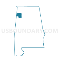
Outline

Summary
| Unique Area Identifier | 522459 |
| Name | Byrd FD |
| County | Marion County |
| State | Alabama |
| Area (square miles) | 18.65 |
| Land Area (square miles) | 18.65 |
| Water Area (square miles) | 0.00 |
| % of Land Area | 100.00 |
| % of Water Area | 0.00 |
| Latitude of the Internal Point | 34.08927090 |
| Longtitude of the Internal Point | -88.10800110 |
Maps


Graphs
Select a template below for downloading or customizing gragh for Byrd FD, Marion County, Alabama


Neighbors
Neighoring Voting District (by Name) Neighboring Voting District on the Map
- Barnsville Church, Marion County, AL
- Detroit-Millville-City Hall, Lamar County, AL
- Hamilton Neighborhood Facilities Bldg, Marion County, AL
- Henson Springs-Fire Station, Lamar County, AL
- Kemp Pleasent Site Church, Marion County, AL
- Old Bexar Post Office, Marion County, AL
Top 10 Neighboring County Subdivision (by Population) Neighboring County Subdivision on the Map
- Hamilton CCD, Marion County, AL (10,275)
- Sulligent CCD, Lamar County, AL (4,689)
- Bexar CCD, Marion County, AL (1,560)
Top 10 Neighboring Place (by Population) Neighboring Place on the Map
Top 10 Neighboring Unified School District (by Population) Neighboring Unified School District on the Map
Top 10 Neighboring State Legislative District Lower Chamber (by Population) Neighboring State Legislative District Lower Chamber on the Map
Top 10 Neighboring State Legislative District Upper Chamber (by Population) Neighboring State Legislative District Upper Chamber on the Map
Top 10 Neighboring 111th Congressional District (by Population) Neighboring 111th Congressional District on the Map
Top 10 Neighboring Census Tract (by Population) Neighboring Census Tract on the Map
- Census Tract 9644, Marion County, AL (5,818)
- Census Tract 300, Lamar County, AL (4,689)
- Census Tract 9642, Marion County, AL (1,560)